Haworth and Stanbury
| Haworth and Stanbury | |
| Civil parish | |
 Haworth | |
| Land |  Storbritannien Storbritannien |
|---|---|
| Riksdel | England |
| Grevskap | West Yorkshire |
| Storstadsdistrikt | Bradford |
| Koordinater | 53°49′51″N 1°58′30″V / 53.8307°N 1.9750°V / 53.8307; -1.9750 |
| Grundad | 2023 |
| Datum | 1 april |
| Tidszon | UTC (UTC+0) |
| - sommartid | BST (UTC+1) |
  Läge i Storbritannien | |

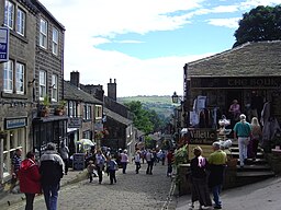
Haworth and Stanbury är en civil parish i distriktet Bradford, i grevskapet West Yorkshire, i England.[1] Civil parish är belägen 15 km från Bradford. Det inkluderar Haworth, Hole, Lumb Foot och Stanbury. Civil parishen inrättades den 1 april 2023.[2]
Referenser
- ^ ”Haworth and Stanbury”. MapIt. https://mapit.mysociety.org/area/168102.html. Läst 10 maj 2023.
- ^ ”Report of the Director of Legal and Governance to the meeting of Council on Tuesday, 13 December 2022”. Bradford City Council. https://bradford.moderngov.co.uk/documents/s40388/Item%2014%20-%20Community%20Governance%20Review%20for%20changes%20to%20Local%20Council%20arrangements%20in%20the%20Haworth%20Cros.pdf. Läst 10 maj 2023.
Externa länkar
 Wikimedia Commons har media som rör Haworth and Stanbury.
| ||||||||||||||


