Moray Firth
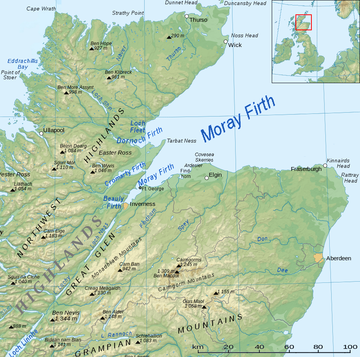
Moray Firth är en trattformig fjord av Nordsjön på Skottlands norra kust, vid mynningen omkring 100 kilometer bred.
I Moray Firth ligger Smith Bank med ett djup av 35 meter. Moray Firth står genom Kaledoniska kanalen i förbindelse med Atlanten och var under första världskriget operationsbas för delar av brittiska flottan.
Källor
- Carlquist, Gunnar, red (1937). Svensk uppslagsbok. Bd 18. Malmö: Svensk Uppslagsbok AB. sid. 118
Externa länkar
- Kartor
- Bartholomew Half Inch to the Mile Maps: Sheet 21 - Inverness & Spey
- National Library of Scotland → Kartor: Sheet 28 - Inverness (1961)
- Geologi
- Poster av Moray Fjordens geologi
- Coastal Assessment Survey: Inner Moray Firth (Sept 1999)
- Scottish Natural Heritage No 50 (1996): The Dornoch, Cromarty and Beauly/Inverness Firths
- Scottish Natural Heritage No 51 (1996): Estuaries of the Outer Moray Firth
- Morphology and significance of transverse ridges (de Geer moraines) adjacent to the Moray Firth, NE SCotland
- Ardesier Peninsula part of a suite of glaciomarine ice-contact deposits
- Biologi och naturskyd
- UK governent website re its status as a protected site
- Scottish government press release about seal management in the firth
- The Moray Firth Wildlife Centre
- The Moray Firth Partnership
- Whale and Dolphin Conservation Society


