Dorchester County (South Carolina)
| Verwaltung | |
|---|---|
| US-Bundesstaat: | South Carolina |
| Verwaltungssitz: | St. George |
| Adresse des Verwaltungssitzes: | County Courthouse 201 Johnson Street St. George, SC 29477-2412 |
| Gründung: | 1868 |
| Vorwahl: | 001 843 |
| Demographie | |
| Einwohner: | 161.540 (Stand: 2020) |
| Bevölkerungsdichte: | 108,49 Einwohner/km2 |
| Geographie | |
| Fläche gesamt: | 1494 km² |
| Wasserfläche: | 5 km² |
| Karte | |
 | |
| Website: www.dorchestercounty.net | |
Dorchester County[1] ist ein County im US-Bundesstaat South Carolina der Vereinigten Staaten. Das U.S. Census Bureau hat bei der Volkszählung 2020 eine Einwohnerzahl von 161.540[2] ermittelt. Der Verwaltungssitz (County Seat) ist St. George.
Geographie
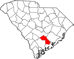
Das County liegt im mittleren Südosten von South Carolina, ist etwa 45 km vom Atlantischen Ozean entfernt und hat eine Fläche von 1494 Quadratkilometern, wovon 5 Quadratkilometer Wasserfläche sind. Es grenzt im Uhrzeigersinn an folgende Countys: Berkeley County, Charleston County, Colleton County, Bamberg County und Orangeburg County.
Geschichte
Das Dorchester County wurde am 25. Februar 1897 aus Teilen der Bezirke Colleton und Berkeley gebildet. Benannt wurde es nach der Stadt Dorchester, die 1696 von Menschen aus Dorchester in Massachusetts gegründet wurde.[3][4]

Ein Ort im County hat den Status einer National Historic Landmark, die Plantage Middleton Place.[5] Zehn Bauwerke und Stätten des Countys sind im National Register of Historic Places (NRHP) eingetragen (Stand 27. Juli 2018).[6]
| Bevölkerungsentwicklung | |||
|---|---|---|---|
| Census | Einwohner | ± rel. | |
| 1900 | 16.294 | — | |
| 1910 | 17.891 | 9,8 % | |
| 1920 | 19.459 | 8,8 % | |
| 1930 | 18.956 | −2,6 % | |
| 1940 | 19.928 | 5,1 % | |
| 1950 | 22.601 | 13,4 % | |
| 1960 | 24.383 | 7,9 % | |
| 1970 | 32.276 | 32,4 % | |
| 1980 | 58.761 | 82,1 % | |
| 1990 | 83.060 | 41,4 % | |
| 2000 | 96.413 | 16,1 % | |
| 2010 | 136.555 | 41,6 % | |
| 2020 | 161.540 | 18,3 % | |
| Zahlen nach United States Census | |||

Orte im Dorchester County
Im Dorchester County liegen sieben Gemeinden, darunter die City North Charleston, und sechs weitere Towns. Alle weiteren benannten Ortslagen haben keine Selbstverwaltung, sind also nur Nachbarschaften in den Gemeinden oder als sogenannte unincorporated Communities gemeindefreies Gebiet.
Gemeinden
- Harleyville
- Lincolnville2
- North Charleston1
- Reevesville
- Ridgeville
- St. George
- Summerville1
1
teilweise im Berkeley County und Charleston County
2
größtenteils im Charleston County
Weitere Orte
- Archdale (32° 54′ N, 80° 6′ W32.9001739-80.0964803)[7]
- Ashborough (32° 58′ N, 80° 11′ W32.9601719-80.187594)[8]
- Ashborough East (32° 58′ N, 80° 11′ W32.9604498-80.1798159)[9]
- Ashley Forest (32° 58′ N, 80° 12′ W32.9657273-80.2000945)[10]
- Ashley Retreat (32° 58′ N, 80° 15′ W32.9662825-80.2450964)[11]
- Avenue of Oaks (32° 58′ N, 80° 9′ W32.964061-80.1473144)[12]
- Azalea Estates (33° 2′ N, 80° 12′ W33.0410032-80.2012044)[13]
- Badham (33° 12′ N, 80° 37′ W33.1957177-80.6112086)[14]
- Barney Ridge (32° 58′ N, 80° 12′ W32.9696161-80.1942608)[15]
- Briarwood (32° 59′ N, 80° 10′ W32.9901713-80.1748152)[16]
- Brick Yard Trace (33° 2′ N, 80° 10′ W33.0254484-80.1609251)[17]
- Brownsville (33° 2′ N, 80° 12′ W33.0287813-80.1981489)[18]
- Byrds (33° 10′ N, 80° 31′ W33.1690522-80.5170429)[19]
- Calomet Valley (32° 58′ N, 80° 11′ W32.9646162-80.186205)[20]
- Canaan (32° 58′ N, 80° 18′ W32.9657267-80.2942642)[21]
- Cat Hole (33° 9′ N, 80° 42′ W33.1446073-80.6939866)[22]
- Centerville (33° 0′ N, 80° 10′ W32.9957268-80.1703705)[23]
- Challendon (33° 1′ N, 80° 10′ W33.0146152-80.1664811)[24]
- Chandler Village (32° 59′ N, 80° 9′ W32.9785051-80.1470363)[25]
- Clemson Terrace (33° 3′ N, 80° 12′ W33.0501697-80.2006487)[26]
- Clubhouse Crossroads (32° 54′ N, 80° 19′ W32.8979508-80.3225988)[27]
- Coachmans Corners (32° 58′ N, 80° 18′ W32.9679488-80.3017643)[28]
- Cooke Crossroads (32° 57′ N, 80° 12′ W32.9482277-80.2056505)[29]
- Corey Point (33° 1′ N, 80° 13′ W33.0098927-80.2164835)[30]
- Corey Wood (33° 1′ N, 80° 13′ W33.0157259-80.2184279)[31]
- Cotton Hill (33° 1′ N, 80° 14′ W33.0090592-80.2414847)[32]
- Country Club Estates (33° 0′ N, 80° 12′ W32.9993376-80.2034275)[33]
- Coventry Place (32° 57′ N, 80° 10′ W32.95545-80.1642597)[34]
- Creekside (32° 58′ N, 80° 12′ W32.9737827-80.1950942)[35]
- Crestwood (32° 58′ N, 80° 12′ W32.9718382-80.2034278)[36]
- Crichton Parish (32° 57′ N, 80° 10′ W32.9557278-80.1703711)[37]
- Dorange (33° 13′ N, 80° 42′ W33.2226612-80.7067631)[38]
- Dorchester (33° 8′ N, 80° 24′ W33.1398875-80.3942635)[39]
- Dorchester Crossing (32° 58′ N, 80° 10′ W32.9585054-80.1648153)[40]
- Dorchester Estates (32° 58′ N, 80° 12′ W32.9679495-80.1967609)[41]
- Dorchester Manor (32° 55′ N, 80° 6′ W32.9246177-80.1020355)[42]
- Duncan Chapel (33° 18′ N, 80° 34′ W33.2959941-80.560373)[43]
- Evergreen (32° 59′ N, 80° 12′ W32.9801714-80.1959274)[44]
- Fairlawn Terrace (32° 59′ N, 80° 8′ W32.9751719-80.1400917)[45]
- Farmdale (32° 58′ N, 80° 13′ W32.973227-80.2206508)[46]
- Flowertown Estates (33° 2′ N, 80° 11′ W33.0387812-80.1787034)[47]
- Flowertown Village (33° 0′ N, 80° 13′ W32.9943375-80.2234285)[48]
- Gadsden Acres (33° 1′ N, 80° 12′ W33.0173926-80.2028716)[49]
- Gadsden Place (33° 2′ N, 80° 12′ W33.026837-80.1925932)[50]
- Gettysville (32° 54′ N, 80° 22′ W32.9018395-80.3639885)[51]
- Giant (33° 14′ N, 80° 27′ W33.2371063-80.4448185)[52]
- Givhans (33° 1′ N, 80° 20′ W33.0115585-80.3375979)[53]
- Greenhurst (33° 0′ N, 80° 10′ W32.9918381-80.161759)[54]
- Greggs Landing (32° 56′ N, 80° 9′ W32.9285062-80.153982)[55]
- Grover (33° 6′ N, 80° 36′ W33.1051646-80.5948212)[56]
- Hudsontown (33° 12′ N, 80° 35′ W33.2059952-80.5909307)[57]
- Hunters Creek (33° 2′ N, 80° 13′ W33.0348921-80.2159274)[58]
- Huntington Farms (33° 1′ N, 80° 13′ W33.0243368-80.2164833)[59]
- Indian Springs (32° 59′ N, 80° 14′ W32.9890598-80.2287066)[60]
- Iron Gate (32° 59′ N, 80° 11′ W32.977116-80.175371)[61]
- Jamison Terrace (32° 59′ N, 80° 9′ W32.977394-80.1453697)[62]
- Jedburg (33° 3′ N, 80° 14′ W33.0557247-80.2384281)[63]
- Kings Grant (32° 56′ N, 80° 9′ W32.9398949-80.1512039)[64]
- Knightsville (33° 1′ N, 80° 14′ W33.0115592-80.2378734)[65]
- Laurel Hill (33° 0′ N, 80° 10′ W32.9973934-80.1692592)[66]
- Lincoln Green (33° 9′ N, 80° 26′ W33.1487758-80.4287086)[67]
- Lotts Crossroads (33° 2′ N, 80° 15′ W33.0410027-80.2492622)[68]
- Marlin Estates (33° 0′ N, 80° 12′ W32.9918378-80.1950939)[69]
- Meadowbrook (33° 1′ N, 80° 10′ W33.017393-80.1648143)[70]
- Millwood (33° 1′ N, 80° 12′ W33.0140594-80.2075941)[71]
- Moss Point (32° 58′ N, 80° 9′ W32.970172-80.1456475)[72]
- Mount Zion (33° 14′ N, 80° 35′ W33.225717-80.5873194)[73]
- Newington Plantation (32° 59′ N, 80° 12′ W32.9848934-80.2053723)[74]
- Norman Landing (32° 59′ N, 80° 25′ W32.9846143-80.408433)[75]
- Oak Knoll Estates (33° 0′ N, 80° 10′ W33.0012822-80.1723149)[76]
- Oakbrook (32° 58′ N, 80° 10′ W32.9585054-80.1720378)[77]
- Oakdale Estates (33° 0′ N, 80° 13′ W32.9960042-80.2131502)[78]
- Oakmont (32° 58′ N, 80° 9′ W32.9654499-80.1445365)[79]
- Old Fort Estates (32° 57′ N, 80° 8′ W32.9576724-80.1300916)[80]
- Old Saint George (33° 10′ N, 80° 37′ W33.1712738-80.6123201)[81]
- Orchard Hill (33° 2′ N, 80° 13′ W33.0254479-80.2225946)[82]
- Palmetto Park (33° 2′ N, 80° 10′ W33.0371146-80.1734254)[83]
- Pecan Grove (33° 1′ N, 80° 14′ W33.0235033-80.2309283)[84]
- Pepperidge (32° 56′ N, 80° 5′ W32.9265623-80.0831457)[85]
- Pine Forest Estates (33° 0′ N, 80° 13′ W33.0037818-80.2150947)[86]
- Pineforest Inn (33° 0′ N, 80° 12′ W33.0076707-80.1962048)[87]
- Pinehill (33° 2′ N, 80° 14′ W33.0412807-80.2314836)[88]
- Plantation Ridge (32° 57′ N, 80° 9′ W32.9551723-80.1534259)[89]
- Pregnall (33° 9′ N, 80° 28′ W33.1562753-80.4645425)[90]
- Quail Arbor (32° 59′ N, 80° 11′ W32.986838-80.1859269)[91]
- Robynwyn (33° 2′ N, 80° 11′ W33.0362813-80.1839815)[92]
- Rosehill (33° 0′ N, 80° 11′ W33.0032265-80.1881489)[93]
- Rosinville (33° 15′ N, 80° 32′ W33.2546052-80.5275969)[94]
- Russell Lake Landing (33° 4′ N, 80° 27′ W33.0623893-80.4567661)[95]
- Salisbury Acres (32° 59′ N, 80° 12′ W32.9876712-80.1953718)[96]
- Sawmill Terrace (33° 0′ N, 80° 10′ W33.0076709-80.1748149)[97]
- Scotch Range Estates (33° 1′ N, 80° 17′ W33.0165587-80.2845412)[98]
- Shephard Park (33° 1′ N, 80° 12′ W33.0087818-80.201205)[99]
- Slandsville (32° 59′ N, 80° 14′ W32.9804489-80.241485)[100]
- Southern Palms (32° 59′ N, 80° 8′ W32.9821162-80.1337024)[101]
- Sprucewood (32° 57′ N, 80° 13′ W32.9473943-80.2164843)[102]
- Stallsville (33° 0′ N, 80° 11′ W32.99656-80.1820376)[103]
- Stratton Capers (32° 56′ N, 80° 6′ W32.9251733-80.0984242)[104]
- Sugar Hill (33° 13′ N, 80° 40′ W33.2126615-80.6609302)[105]
- Summerset Acres (33° 2′ N, 80° 17′ W33.0312805-80.2773185)[106]
- Summerville Farms (32° 58′ N, 80° 13′ W32.9737825-80.2156506)[107]
- Summerville Place (32° 59′ N, 80° 8′ W32.9862827-80.1414804)[108]
- Summerwood (32° 58′ N, 80° 8′ W32.9715609-80.1387028)[109]
- Sweetbriar (33° 1′ N, 80° 15′ W33.0187811-80.2462069)[110]
- Tea Farm (33° 0′ N, 80° 12′ W33.0018376-80.1945381)[111]
- Texas (33° 8′ N, 80° 33′ W33.1321086-80.55371)[112]
- Tranquil Acres (32° 58′ N, 80° 9′ W32.9585055-80.1567593)[113]
- Tranquil Estates (32° 58′ N, 80° 9′ W32.9676721-80.1428697)[114]
- Trotters Ridge (33° 2′ N, 80° 14′ W33.0254478-80.2270392)[115]
- Twin Lakes (33° 0′ N, 80° 16′ W33.0023925-80.2745412)[116]
- Twin Oaks (33° 0′ N, 80° 11′ W33.0018377-80.1803709)[117]
- University Park (32° 55′ N, 80° 6′ W32.9196179-80.0950909)[118]
- Waring Hall (33° 1′ N, 80° 13′ W33.0154482-80.2125943)[119]
- Warington (33° 1′ N, 80° 12′ W33.0132261-80.2039829)[120]
- Waters Edge (32° 57′ N, 80° 10′ W32.9487834-80.1675933)[121]
- West Oaks (32° 57′ N, 80° 13′ W32.9473942-80.2225957)[122]
- Westoe (32° 57′ N, 80° 14′ W32.9460053-80.2334295)[123]
- White Church Place (32° 58′ N, 80° 12′ W32.9635051-80.1956498)[124]
- Wood Oak Park (33° 0′ N, 80° 10′ W32.9940602-80.1687038)[125]
- Woodland Estates (32° 59′ N, 80° 12′ W32.980727-80.1984275)[126]
- Woodlawn (33° 0′ N, 80° 11′ W32.9923934-80.1828711)[127]
Siehe auch
Einzelnachweise
- ↑ Dorchester County. In: Geographic Names Information System. United States Geological Survey, United States Department of the Interior; abgerufen im 1. Januar 1 (englisch). . Abgerufen am 22. Februar 2011
- ↑ Explore Census Data Total Population in Dorchester County, South Carolina. Abgerufen am 19. März 2023.
- ↑ Alexander Moore: Dorchester County. In: South Carolina Encyclopedia. University of South Carolina, Institute for Southern Studies, 17. Mai 2016, abgerufen am 7. Oktober 2022 (amerikanisches Englisch).
- ↑ Charles Curry Aiken, Joseph Nathan Kane: The American Counties: Origins of County Names, Dates of Creation, Area, and Population Data, 1950–2010. 6. Auflage. Scarecrow Press, Lanham 2013, ISBN 978-0-8108-8762-6, S. 88.
- ↑ Listing of National Historic Landmarks by State: South Carolina. National Park Service, abgerufen am 27. Juli 2018.
- ↑ Suchmaske Datenbank im National Register Information System. National Park Service, abgerufen am 27. Juli 2018.
- ↑ Archdale. In: Geographic Names Information System. United States Geological Survey, United States Department of the Interior; abgerufen im 1. Januar 1 (englisch).
- ↑ Ashborough. In: Geographic Names Information System. United States Geological Survey, United States Department of the Interior; abgerufen im 1. Januar 1 (englisch).
- ↑ Ashborough East. In: Geographic Names Information System. United States Geological Survey, United States Department of the Interior; abgerufen im 1. Januar 1 (englisch).
- ↑ Ashley Forest. In: Geographic Names Information System. United States Geological Survey, United States Department of the Interior; abgerufen im 1. Januar 1 (englisch).
- ↑ Ashley Retreat. In: Geographic Names Information System. United States Geological Survey, United States Department of the Interior; abgerufen im 1. Januar 1 (englisch).
- ↑ Avenue of Oaks. In: Geographic Names Information System. United States Geological Survey, United States Department of the Interior; abgerufen im 1. Januar 1 (englisch).
- ↑ Azalea Estates. In: Geographic Names Information System. United States Geological Survey, United States Department of the Interior; abgerufen im 1. Januar 1 (englisch).
- ↑ Badham. In: Geographic Names Information System. United States Geological Survey, United States Department of the Interior; abgerufen im 1. Januar 1 (englisch).
- ↑ Barney Ridge. In: Geographic Names Information System. United States Geological Survey, United States Department of the Interior; abgerufen im 1. Januar 1 (englisch).
- ↑ Briarwood. In: Geographic Names Information System. United States Geological Survey, United States Department of the Interior; abgerufen im 1. Januar 1 (englisch).
- ↑ Brick Yard Trace. In: Geographic Names Information System. United States Geological Survey, United States Department of the Interior; abgerufen im 1. Januar 1 (englisch).
- ↑ Brownsville. In: Geographic Names Information System. United States Geological Survey, United States Department of the Interior; abgerufen im 1. Januar 1 (englisch).
- ↑ Byrd. In: Geographic Names Information System. United States Geological Survey, United States Department of the Interior; abgerufen im 1. Januar 1 (englisch).
- ↑ Calomet Valley. In: Geographic Names Information System. United States Geological Survey, United States Department of the Interior; abgerufen im 1. Januar 1 (englisch).
- ↑ Canaan. In: Geographic Names Information System. United States Geological Survey, United States Department of the Interior; abgerufen im 1. Januar 1 (englisch).
- ↑ Cat Hole. In: Geographic Names Information System. United States Geological Survey, United States Department of the Interior; abgerufen im 1. Januar 1 (englisch).
- ↑ Centerville. In: Geographic Names Information System. United States Geological Survey, United States Department of the Interior; abgerufen im 1. Januar 1 (englisch).
- ↑ Challendon. In: Geographic Names Information System. United States Geological Survey, United States Department of the Interior; abgerufen im 1. Januar 1 (englisch).
- ↑ Chandler Village. In: Geographic Names Information System. United States Geological Survey, United States Department of the Interior; abgerufen im 1. Januar 1 (englisch).
- ↑ Clemson Terrace. In: Geographic Names Information System. United States Geological Survey, United States Department of the Interior; abgerufen im 1. Januar 1 (englisch).
- ↑ Clubhouse Crossroads. In: Geographic Names Information System. United States Geological Survey, United States Department of the Interior; abgerufen im 1. Januar 1 (englisch).
- ↑ Coachmans Corners. In: Geographic Names Information System. United States Geological Survey, United States Department of the Interior; abgerufen im 1. Januar 1 (englisch).
- ↑ Cooke Crossroads. In: Geographic Names Information System. United States Geological Survey, United States Department of the Interior; abgerufen im 1. Januar 1 (englisch).
- ↑ Corey Point. In: Geographic Names Information System. United States Geological Survey, United States Department of the Interior; abgerufen im 1. Januar 1 (englisch).
- ↑ Corey Wood. In: Geographic Names Information System. United States Geological Survey, United States Department of the Interior; abgerufen im 1. Januar 1 (englisch).
- ↑ Cotton Hill. In: Geographic Names Information System. United States Geological Survey, United States Department of the Interior; abgerufen im 1. Januar 1 (englisch).
- ↑ Country Club Estates. In: Geographic Names Information System. United States Geological Survey, United States Department of the Interior; abgerufen im 1. Januar 1 (englisch).
- ↑ Coventry Place. In: Geographic Names Information System. United States Geological Survey, United States Department of the Interior; abgerufen im 1. Januar 1 (englisch).
- ↑ Creekside. In: Geographic Names Information System. United States Geological Survey, United States Department of the Interior; abgerufen im 1. Januar 1 (englisch).
- ↑ Crestwood. In: Geographic Names Information System. United States Geological Survey, United States Department of the Interior; abgerufen im 1. Januar 1 (englisch).
- ↑ Crichton Parish. In: Geographic Names Information System. United States Geological Survey, United States Department of the Interior; abgerufen im 1. Januar 1 (englisch).
- ↑ Dorange. In: Geographic Names Information System. United States Geological Survey, United States Department of the Interior; abgerufen im 1. Januar 1 (englisch).
- ↑ Dorchester. In: Geographic Names Information System. United States Geological Survey, United States Department of the Interior; abgerufen im 1. Januar 1 (englisch).
- ↑ Dorchester Crossing. In: Geographic Names Information System. United States Geological Survey, United States Department of the Interior; abgerufen im 1. Januar 1 (englisch).
- ↑ Dorchester Estates. In: Geographic Names Information System. United States Geological Survey, United States Department of the Interior; abgerufen im 1. Januar 1 (englisch).
- ↑ Dorchester Manor. In: Geographic Names Information System. United States Geological Survey, United States Department of the Interior; abgerufen im 1. Januar 1 (englisch).
- ↑ Duncan Chapel. In: Geographic Names Information System. United States Geological Survey, United States Department of the Interior; abgerufen im 1. Januar 1 (englisch).
- ↑ Evergreen. In: Geographic Names Information System. United States Geological Survey, United States Department of the Interior; abgerufen im 1. Januar 1 (englisch).
- ↑ Fairlawn Terrace. In: Geographic Names Information System. United States Geological Survey, United States Department of the Interior; abgerufen im 1. Januar 1 (englisch).
- ↑ Farmdale. In: Geographic Names Information System. United States Geological Survey, United States Department of the Interior; abgerufen im 1. Januar 1 (englisch).
- ↑ Flowertown Estates. In: Geographic Names Information System. United States Geological Survey, United States Department of the Interior; abgerufen im 1. Januar 1 (englisch).
- ↑ Flowertown Village. In: Geographic Names Information System. United States Geological Survey, United States Department of the Interior; abgerufen im 1. Januar 1 (englisch).
- ↑ Gadsden Acres. In: Geographic Names Information System. United States Geological Survey, United States Department of the Interior; abgerufen im 1. Januar 1 (englisch).
- ↑ Gadsden Place. In: Geographic Names Information System. United States Geological Survey, United States Department of the Interior; abgerufen im 1. Januar 1 (englisch).
- ↑ Gettysville. In: Geographic Names Information System. United States Geological Survey, United States Department of the Interior; abgerufen im 1. Januar 1 (englisch).
- ↑ Giant. In: Geographic Names Information System. United States Geological Survey, United States Department of the Interior; abgerufen im 1. Januar 1 (englisch).
- ↑ Givhans. In: Geographic Names Information System. United States Geological Survey, United States Department of the Interior; abgerufen im 1. Januar 1 (englisch).
- ↑ Greenhurst. In: Geographic Names Information System. United States Geological Survey, United States Department of the Interior; abgerufen im 1. Januar 1 (englisch).
- ↑ Greggs Landing. In: Geographic Names Information System. United States Geological Survey, United States Department of the Interior; abgerufen im 1. Januar 1 (englisch).
- ↑ Grover. In: Geographic Names Information System. United States Geological Survey, United States Department of the Interior; abgerufen im 1. Januar 1 (englisch).
- ↑ Hudsontown. In: Geographic Names Information System. United States Geological Survey, United States Department of the Interior; abgerufen im 1. Januar 1 (englisch).
- ↑ Hunters Creek. In: Geographic Names Information System. United States Geological Survey, United States Department of the Interior; abgerufen im 1. Januar 1 (englisch).
- ↑ Huntington Farms. In: Geographic Names Information System. United States Geological Survey, United States Department of the Interior; abgerufen im 1. Januar 1 (englisch).
- ↑ Indian Springs. In: Geographic Names Information System. United States Geological Survey, United States Department of the Interior; abgerufen im 1. Januar 1 (englisch).
- ↑ Iron Gate. In: Geographic Names Information System. United States Geological Survey, United States Department of the Interior; abgerufen im 1. Januar 1 (englisch).
- ↑ Jamison Terrace. In: Geographic Names Information System. United States Geological Survey, United States Department of the Interior; abgerufen im 1. Januar 1 (englisch).
- ↑ Jedburg. In: Geographic Names Information System. United States Geological Survey, United States Department of the Interior; abgerufen im 1. Januar 1 (englisch).
- ↑ Kings Grant. In: Geographic Names Information System. United States Geological Survey, United States Department of the Interior; abgerufen im 1. Januar 1 (englisch).
- ↑ Knightsville. In: Geographic Names Information System. United States Geological Survey, United States Department of the Interior; abgerufen im 1. Januar 1 (englisch).
- ↑ Laurel Hill. In: Geographic Names Information System. United States Geological Survey, United States Department of the Interior; abgerufen im 1. Januar 1 (englisch).
- ↑ Lincoln Green. In: Geographic Names Information System. United States Geological Survey, United States Department of the Interior; abgerufen im 1. Januar 1 (englisch).
- ↑ Lotts Crossroads. In: Geographic Names Information System. United States Geological Survey, United States Department of the Interior; abgerufen im 1. Januar 1 (englisch).
- ↑ Marlin Estates. In: Geographic Names Information System. United States Geological Survey, United States Department of the Interior; abgerufen im 1. Januar 1 (englisch).
- ↑ Meadowbrook. In: Geographic Names Information System. United States Geological Survey, United States Department of the Interior; abgerufen im 1. Januar 1 (englisch).
- ↑ Millwood. In: Geographic Names Information System. United States Geological Survey, United States Department of the Interior; abgerufen im 1. Januar 1 (englisch).
- ↑ Moss Point. In: Geographic Names Information System. United States Geological Survey, United States Department of the Interior; abgerufen im 1. Januar 1 (englisch).
- ↑ Mount Zion. In: Geographic Names Information System. United States Geological Survey, United States Department of the Interior; abgerufen im 1. Januar 1 (englisch).
- ↑ Newington Plantation. In: Geographic Names Information System. United States Geological Survey, United States Department of the Interior; abgerufen im 1. Januar 1 (englisch).
- ↑ Norman Landing. In: Geographic Names Information System. United States Geological Survey, United States Department of the Interior; abgerufen im 1. Januar 1 (englisch).
- ↑ Oak Knoll Estates. In: Geographic Names Information System. United States Geological Survey, United States Department of the Interior; abgerufen im 1. Januar 1 (englisch).
- ↑ Oakbrook. In: Geographic Names Information System. United States Geological Survey, United States Department of the Interior; abgerufen im 1. Januar 1 (englisch).
- ↑ Oakdale Estates. In: Geographic Names Information System. United States Geological Survey, United States Department of the Interior; abgerufen im 1. Januar 1 (englisch).
- ↑ Oakmont. In: Geographic Names Information System. United States Geological Survey, United States Department of the Interior; abgerufen im 1. Januar 1 (englisch).
- ↑ Old Fort Estates. In: Geographic Names Information System. United States Geological Survey, United States Department of the Interior; abgerufen im 1. Januar 1 (englisch).
- ↑ Old Saint George. In: Geographic Names Information System. United States Geological Survey, United States Department of the Interior; abgerufen im 1. Januar 1 (englisch).
- ↑ Orchard Hill. In: Geographic Names Information System. United States Geological Survey, United States Department of the Interior; abgerufen im 1. Januar 1 (englisch).
- ↑ Palmetto Park. In: Geographic Names Information System. United States Geological Survey, United States Department of the Interior; abgerufen im 1. Januar 1 (englisch).
- ↑ Pecan Grove. In: Geographic Names Information System. United States Geological Survey, United States Department of the Interior; abgerufen im 1. Januar 1 (englisch).
- ↑ Pepperidge. In: Geographic Names Information System. United States Geological Survey, United States Department of the Interior; abgerufen im 1. Januar 1 (englisch).
- ↑ Pine Forest Estates. In: Geographic Names Information System. United States Geological Survey, United States Department of the Interior; abgerufen im 1. Januar 1 (englisch).
- ↑ Pineforest Inn. In: Geographic Names Information System. United States Geological Survey, United States Department of the Interior; abgerufen im 1. Januar 1 (englisch).
- ↑ Pinehill. In: Geographic Names Information System. United States Geological Survey, United States Department of the Interior; abgerufen im 1. Januar 1 (englisch).
- ↑ Plantation Ridge. In: Geographic Names Information System. United States Geological Survey, United States Department of the Interior; abgerufen im 1. Januar 1 (englisch).
- ↑ Pregnall. In: Geographic Names Information System. United States Geological Survey, United States Department of the Interior; abgerufen im 1. Januar 1 (englisch).
- ↑ Quail Arbor. In: Geographic Names Information System. United States Geological Survey, United States Department of the Interior; abgerufen im 1. Januar 1 (englisch).
- ↑ Robynwyn. In: Geographic Names Information System. United States Geological Survey, United States Department of the Interior; abgerufen im 1. Januar 1 (englisch).
- ↑ Rosehill. In: Geographic Names Information System. United States Geological Survey, United States Department of the Interior; abgerufen im 1. Januar 1 (englisch).
- ↑ Rosinville. In: Geographic Names Information System. United States Geological Survey, United States Department of the Interior; abgerufen im 1. Januar 1 (englisch).
- ↑ Russell Lake Landing. In: Geographic Names Information System. United States Geological Survey, United States Department of the Interior; abgerufen im 1. Januar 1 (englisch).
- ↑ Salisbury Acres. In: Geographic Names Information System. United States Geological Survey, United States Department of the Interior; abgerufen im 1. Januar 1 (englisch).
- ↑ Sawmill Terrace. In: Geographic Names Information System. United States Geological Survey, United States Department of the Interior; abgerufen im 1. Januar 1 (englisch).
- ↑ Scotch Range Estates. In: Geographic Names Information System. United States Geological Survey, United States Department of the Interior; abgerufen im 1. Januar 1 (englisch).
- ↑ Shephard Park. In: Geographic Names Information System. United States Geological Survey, United States Department of the Interior; abgerufen im 1. Januar 1 (englisch).
- ↑ Slandsville. In: Geographic Names Information System. United States Geological Survey, United States Department of the Interior; abgerufen im 1. Januar 1 (englisch).
- ↑ Southern Palms. In: Geographic Names Information System. United States Geological Survey, United States Department of the Interior; abgerufen im 1. Januar 1 (englisch).
- ↑ Sprucewood. In: Geographic Names Information System. United States Geological Survey, United States Department of the Interior; abgerufen im 1. Januar 1 (englisch).
- ↑ Stallsville. In: Geographic Names Information System. United States Geological Survey, United States Department of the Interior; abgerufen im 1. Januar 1 (englisch).
- ↑ Stratton Capers. In: Geographic Names Information System. United States Geological Survey, United States Department of the Interior; abgerufen im 1. Januar 1 (englisch).
- ↑ Sugar Hill. In: Geographic Names Information System. United States Geological Survey, United States Department of the Interior; abgerufen im 1. Januar 1 (englisch).
- ↑ Summerset Acres. In: Geographic Names Information System. United States Geological Survey, United States Department of the Interior; abgerufen im 1. Januar 1 (englisch).
- ↑ Summerville Farms. In: Geographic Names Information System. United States Geological Survey, United States Department of the Interior; abgerufen im 1. Januar 1 (englisch).
- ↑ Summerville Place. In: Geographic Names Information System. United States Geological Survey, United States Department of the Interior; abgerufen im 1. Januar 1 (englisch).
- ↑ Summerwood. In: Geographic Names Information System. United States Geological Survey, United States Department of the Interior; abgerufen im 1. Januar 1 (englisch).
- ↑ Sweetbriar. In: Geographic Names Information System. United States Geological Survey, United States Department of the Interior; abgerufen im 1. Januar 1 (englisch).
- ↑ Tea Farm. In: Geographic Names Information System. United States Geological Survey, United States Department of the Interior; abgerufen im 1. Januar 1 (englisch).
- ↑ Texas. In: Geographic Names Information System. United States Geological Survey, United States Department of the Interior; abgerufen im 1. Januar 1 (englisch).
- ↑ Tranquil Acres. In: Geographic Names Information System. United States Geological Survey, United States Department of the Interior; abgerufen im 1. Januar 1 (englisch).
- ↑ Tranquil Estates. In: Geographic Names Information System. United States Geological Survey, United States Department of the Interior; abgerufen im 1. Januar 1 (englisch).
- ↑ Trotters Ridge. In: Geographic Names Information System. United States Geological Survey, United States Department of the Interior; abgerufen im 1. Januar 1 (englisch).
- ↑ Twin Lakes. In: Geographic Names Information System. United States Geological Survey, United States Department of the Interior; abgerufen im 1. Januar 1 (englisch).
- ↑ Twin Oaks. In: Geographic Names Information System. United States Geological Survey, United States Department of the Interior; abgerufen im 1. Januar 1 (englisch).
- ↑ University Park. In: Geographic Names Information System. United States Geological Survey, United States Department of the Interior; abgerufen im 1. Januar 1 (englisch).
- ↑ Waring Hall. In: Geographic Names Information System. United States Geological Survey, United States Department of the Interior; abgerufen im 1. Januar 1 (englisch).
- ↑ Warington. In: Geographic Names Information System. United States Geological Survey, United States Department of the Interior; abgerufen im 1. Januar 1 (englisch).
- ↑ Waters Edge. In: Geographic Names Information System. United States Geological Survey, United States Department of the Interior; abgerufen im 1. Januar 1 (englisch).
- ↑ West Oaks. In: Geographic Names Information System. United States Geological Survey, United States Department of the Interior; abgerufen im 1. Januar 1 (englisch).
- ↑ Westoe. In: Geographic Names Information System. United States Geological Survey, United States Department of the Interior; abgerufen im 1. Januar 1 (englisch).
- ↑ White Church Place. In: Geographic Names Information System. United States Geological Survey, United States Department of the Interior; abgerufen im 1. Januar 1 (englisch).
- ↑ Wood Oak Park. In: Geographic Names Information System. United States Geological Survey, United States Department of the Interior; abgerufen im 1. Januar 1 (englisch).
- ↑ Woodland Estates. In: Geographic Names Information System. United States Geological Survey, United States Department of the Interior; abgerufen im 1. Januar 1 (englisch).
- ↑ Woodlawn. In: Geographic Names Information System. United States Geological Survey, United States Department of the Interior; abgerufen im 1. Januar 1 (englisch).
Weblinks
Commons: Dorchester County, South Carolina – Sammlung von Bildern, Videos und Audiodateien
- Alexander Moore: Dorchester County. In: South Carolina Encyclopedia .

Countys im US-Bundesstaat South Carolina
Liste der Countys in South Carolina
Abbeville | Aiken | Allendale | Anderson | Bamberg | Barnwell | Beaufort | Berkeley | Calhoun | Charleston | Cherokee | Chester | Chesterfield | Clarendon | Colleton | Darlington | Dillon | Dorchester | Edgefield | Fairfield | Florence | Georgetown | Greenville | Greenwood | Hampton | Horry | Jasper | Kershaw | Lancaster | Laurens | Lee | Lexington | Marion | Marlboro | McCormick | Newberry | Oconee | Orangeburg | Pickens | Richland | Saluda | Spartanburg | Sumter | Union | Williamsburg | York
County Seat: St. George
| City | ||
| Towns | Harleyville • Lincolnville‡ • Reevesville • Ridgeville • St. George • Summerville‡ | |
| CDP | Grover |

‡ Dieser Ort liegt teilweise in einem benachbarten County
Liste der Städte in South Carolina
Liste der Städte in South Carolina
33.08-80.4Koordinaten: 33° 5′ N, 80° 24′ W


