Fort Rock Cave
United States historic place
Fort Rock Cave | |
U.S. National Historic Landmark | |
 University of Oregon archaeological excavations at Fort Rock Cave, 1966 | |
| Location | Address restricted[1] |
|---|---|
| Nearest city | Fort Rock, Oregon |
| NRHP reference No. | 66000641 |
| Significant dates | |
| Added to NRHP | October 15, 1966 |
| Designated NHL | January 20, 1961 |
Fort Rock Cave was the site of the earliest evidence of human habitation in the US state of Oregon before the excavation of the Paisley Caves. Fort Rock Cave featured numerous well-preserved sagebrush sandals, ranging from 9,000 to 13,000 years old.[2] The cave is located approximately 1.5 miles (2.4 km) west of Fort Rock near Fort Rock State Natural Area in Lake County.[3] Fort Rock Cave was declared a National Historic Landmark in 1961, and added to the National Register of Historic Places in 1966.[4]
The cave was found on Reub Long's ranch. It was formerly known as Menkenmaier Cave and Cow Cave.[5][6]
Description
Fort Rock Cave sits in the Fort Rock formation, and shares geological similarities to its surroundings, with presence of Hayes Butte basalt, and exposed Pliocene-era lava.[7][8][9] Additionally, there is pumice and ash from Mount Mazama (deposited by the explosion forming Crater Lake about 7600 years ago).[9] The opening of the cave is approximately 70 feet across, with a depth of near 60 feet, making it the largest cave in the Fort Rock area. Oriented facing the southeast, the combination of depth and position protect it from winds and summer heat.[9] Archaeological excavators identified four stratum of material in the cave: a bottom gravel layer, a silty brown layer, pumice and ash from Mt. Mazama, topped by a light tan sandy layer.[9] Parts of the cave are collapsed, leaving some large boulders, which were involved in the excavations.[9][10]
Excavations
Excavations of the site began in 1938 led by Luther Cressman and his team of University of Oregon, and continued into the next year.[10] At this time, Cressman unearthed a number of sandals, with damage and charring, and used a chemical preservative to prevent further decay. Unknowing at the time, this would prevent radiocarbon dating of these artifacts.[11] Cressman returned as an overseer to Stephen Bedwell in 1966 and 1967, to continue excavating the site. Upon their return, they found that the cave had been looted and vandalized, compromising the integrity of much of the area.[9][10] However, a few areas under large fallen boulders were protected from disturbance, and were excavated at this time.[9] Both periods of excavation provided limited documentation in comparison to modern archaeological data practices, causing issues for further archaeological study of the artifacts removed.[10] Additionally, use of backhoes and dynamite at the site during the excavations in the 60s caused much destruction to the site. Some artifacts recovered during this second period of excavation were able to be dated by the Gakushuin Laboratory, generating further questioning of the integrity of the study, as this lab has generated erroneous data.[10]
Archaeology
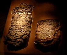
Anthropologist Luther Cressman and his team recovered a significant collection of artifacts from under the Mazama Ash, dating those artifacts to more than 7,000 years ago.[11][12] This collection included wooden artifacts, stone tools, shell beads, obsidian, basket fragments, and, most famously, 95 sandals woven from sagebrush bark (some of these sandals are now displayed at the University of Oregon Museum of Natural and Cultural History and in the town of Fort Rock). While the dry climate helped preserve these ancient sandals, exposure to the ash caused most of them to be charred, leading to Cressman's decision to chemically preserve them. This sandal style is known as Fort Rock style, since they were first discovered there and is distinct from other variants; they are flat, closed toed and have a twined sole.[13] They have been found at other sites, such as Cougar Mountain and Catlow Caves, as well.[14][15] A local Fort Rock resident was responsible for finding a fragment of woven material which was eligible for dating, placing it around 9000 years ago.[12] Some of these woven artifacts had diagonal twining and false embroidery decorative techniques, suggesting that these techniques were present in the region at that time.[10][11] Additional artifacts found after the initial excavations included projectile points, obsidian and stone tools, and faunal remains, as well as more sandals.[10][16] Calibrated radiocarbon dates from this set of artifacts estimated dates in the early Holocene period, approximately 10,000 years ago.[10] The oldest dating from this site comes from a piece of charcoal dated to 13,000 BP, a date that has been debated by some archaeologists.[9]
See also
- Kennewick Man, skeletal remains discovered in the Pasco Basin
- Marmes Rockshelter, on the lower Snake River
- Paisley Caves, also in eastern Oregon, the site of perhaps the oldest human remains in the Americas
- Rimrock Draw Rockshelter, eastern Oregon archaeological site and potentially one of the oldest sites in North America
References
- ^ Federal and state laws and practices restrict general public access to information regarding the specific location of this resource. In some cases, this is to protect archaeological sites from vandalism, while in other cases it is restricted at the request of the owner. See: Knoerl, John; Miller, Diane; Shrimpton, Rebecca H. (1990), Guidelines for Restricting Information about Historic and Prehistoric Resources, National Register Bulletin, National Park Service, U.S. Department of the Interior, OCLC 20706997.
- ^ Robbins, William G. (2005). Oregon: This Storied Land. Oregon Historical Society Press. ISBN 0-87595-286-0.
- ^ "Fort Rock Cave, Oregon". Archeological Society of Central Oregon. Archived from the original on February 11, 2012. Retrieved April 29, 2008.
- ^ Oregon Parks and Recreation Department, Oregon Historic Sites Database, retrieved June 20, 2014.
- ^ Brogan, Phil (June 16, 1975). "Geographic board okays naming cave after Long". The Bulletin. p. 2. Retrieved December 8, 2011.
Board directors said the proposal is not a name change – the cavern, oldest known habitation of man in the region, has been known over the years by various names, Menkenmaier Cave, Fort Rock Cave and Cow Cave. It has been known in recent years as Fort Rock Cave, and this has resulted in much confusion with the Fort Rock formation, about a mile and a half to the east. ... Several years ago, Mr. and Mrs. Long formally presented the cave, on Reub Long's land, to the U.S. Park Service. The cave got its Cow Cavern name because Long's cattle sought shelter there from winter storms. ... The Fort Rock basin cave won national attention in 1938 when Dr. L. S. Cressman, University of Oregon anthropologist, found in the old cave a cache of sandals made from sagebrush.
- ^ "Fort Rock: It's too small for a beer license". The Bulletin. September 1, 1970. p. 7. Retrieved December 8, 2011.
About two miles northwest of the rock is Fort Rock Cave, where the discovery in 1938 of prehistoric sandals established the Fort Rock basin as the oldest known habitat of man in the Oregon country. Anthropologists set the radio-carbon age of the sandals at around 9,000 years. The cave is located on what was once Reub Long's "home" ranch.
- ^ Hampton, E.R. (1964). "Geologic factors that control the occurrence and availability of ground water in the Fort Rock Basin, Lake County, Oregon". Professional Paper. doi:10.3133/pp383b. hdl:2027/uc1.31210020742704. ISSN 2330-7102.
- ^ Bedwell, Stephen F. Prehistory and environment of the pluvial Fort Rock Lake area of south central Oregon. OCLC 3358031.
- ^ a b c d e f g h Bedwell, S. F. (1970). "Prehistory And Environment Of The Pluvial Fort Rock Lake Area Of South Central Oregon". ProQuest. ProQuest 302453386.
- ^ a b c d e f g h Jamaldin, S. A. (2018). Terminal Pleistocene/Early Holocene Cave Use in Oregon's Fort Rock Basin: An Examination of Western Stemmed Tradition Projectile Point Assemblages from Fort Rock Cave, Cougar Mountain Cave, and the Connley Caves (Order No. 10816194). Available from ProQuest Dissertations & Theses Global. (2082266930).
- ^ a b c Connolly, Thomas J. (2013). "Implications of New Radiocarbon Ages on Coiled Basketry from the Northern Great Basin". American Antiquity. 78 (2): 373–384. doi:10.7183/0002-7316.78.2.373. S2CID 164142762.
- ^ a b Aikens, C. Melvin; Jenkins, Dennis L. (1994). Archaeological researches in the northern Great Basin : Fort Rock archaeology since Cressman. Dept. of Anthropology and State Museum of Anthropology, University of Oregon, in collaboration with the Bureau of Land Management. OCLC 32335294.
- ^ "Fort Rock Sandals". Retrieved October 17, 2011.
- ^ "World's Oldest Shoes". University of Oregon. Archived from the original on April 10, 2012. Retrieved April 9, 2007.
- ^ Tucker, Kathy (2002). "Fort Rock Sandals". Oregon Historical Society. Retrieved April 9, 2007.
- ^ "Cultural Sequence in the Northern Great Basin: The View From Fort Rock". University of Oregon Department of Anthropology. Archived from the original on July 15, 2004. Retrieved August 16, 2011.
External links
Wikimedia Commons has media related to Fort Rock Cave.
- Fort Rock Cave information from Oregon Parks and Recreation Department
- Fort Rock Valley Historical Society
- v
- t
- e
Prehistoric cave sites, rock shelters and cave paintings
- Paleoanthropological sites
- Cave paintings
- Caves containing pictograms
Asia | |||||||||||||||||||||||||||||||||||||||||||||||||||||||||
|---|---|---|---|---|---|---|---|---|---|---|---|---|---|---|---|---|---|---|---|---|---|---|---|---|---|---|---|---|---|---|---|---|---|---|---|---|---|---|---|---|---|---|---|---|---|---|---|---|---|---|---|---|---|---|---|---|---|
| |||||||||||||||||||||||||||||||||||||||||||||||||||||||||
Africa | |||||||||||||||||||||||||||||||||||||
|---|---|---|---|---|---|---|---|---|---|---|---|---|---|---|---|---|---|---|---|---|---|---|---|---|---|---|---|---|---|---|---|---|---|---|---|---|---|
| |||||||||||||||||||||||||||||||||||||
North and South America | |||||||||||||||||||||||||||||||
|---|---|---|---|---|---|---|---|---|---|---|---|---|---|---|---|---|---|---|---|---|---|---|---|---|---|---|---|---|---|---|---|
| |||||||||||||||||||||||||||||||
Oceania | |||||||||||||||||||
|---|---|---|---|---|---|---|---|---|---|---|---|---|---|---|---|---|---|---|---|
| |||||||||||||||||||
| |
|---|---|
| |
| Archaeological cultures |
|
| Archaeological sites |
|
| Human remains | |
| Miscellaneous |
|
| |

| ||
|---|---|---|
| Archaeological sites |
|  |
| Ethnicities |
| |
| Languages | ||
| People |
| |
| Places | ||
| Towns and villages | ||
| Armed conflicts | ||
| Court cases and treaties | ||
| Modern issues | ||
| Miscellaneous |
| |
| See also |
| |

| |||||||||||||||||||||||||||||||
|---|---|---|---|---|---|---|---|---|---|---|---|---|---|---|---|---|---|---|---|---|---|---|---|---|---|---|---|---|---|---|---|
| Federal |
| ||||||||||||||||||||||||||||||
| State |
| ||||||||||||||||||||||||||||||
| Local |
| ||||||||||||||||||||||||||||||
| |||||||||||||||||||||||||||||||

| ||
|---|---|---|
| Native |  | |
| Early | ||
| Pioneer |
| |
| Modern | ||
| ||
|---|---|---|
| Lists by county |  | |
| Portland lists | ||
| Other lists |
| |


