Kloa Point
Headland of Antarctica
Kloa Point is a prominent coastal point projecting from the east side of Edward VIII Plateau, 5.6 kilometres (3 nmi) north of Cape Gotley, Antarctica. It was mapped by Norwegian cartographers from aerial photographs taken by the Lars Christensen Expedition, 1936–37, and called by them Kloa ('claw').[1]
Important Bird Area
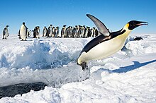
A 289 ha site on fast ice off the southern shore of the point has been designated an Important Bird Area (IBA) by BirdLife International because it supports about 3,300 breeding pairs of emperor penguins (Aptenodytes forsteri), based on 2009 satellite imagery.
Other birds observed in the vicinity of Kloa Point include the Adélie penguin (Pygoscelis adeliae), Antarctic tern (Sterna vittata), South polar skua (Stercorarius maccormicki), Southern fulmar (Fulmarus glacialoides), Snow petrel (Pagodroma nivea), Weddell seal (Leptonychotes weddellii), and Wilson's storm petrel (Oceanites oceanicus).[2]
References
- ^ "Kloa Point". Geographic Names Information System. United States Geological Survey, United States Department of the Interior. Retrieved 2013-05-10.
- ^ "Important Bird Areas factsheet: Kloa Point". BirdLife Data Zone. BirdLife International. 2021. Retrieved 30 March 2021.
External links
 This article incorporates public domain material from "Kloa Point". Geographic Names Information System. United States Geological Survey.
66°38′S 57°19′E / 66.633°S 57.317°E / -66.633; 57.317
- v
- t
- e
Important Bird Areas of Antarctica
- Kloa Point
- Amanda Bay
- Bluff Island
- Boyd Island
- Caro Island
- Donskiye Islands
- Filla Island
- Gardner Island
- Hop Island
- Kazak Island
- Lucas Island
- Lugg Island
- Magnetic Island
- Rookery Lake
- Tryne Islands
- Turner Island
- Warriner Island
- Waterhouse Island
- West Ice Shelf
- Zolotov Island
- Arthurson Ridge
- Kartografov Island
- Mount Archer
- Sturge Island
- Adélie Cove
- Blue Glacier to Cape Chocolate
- Cape Adare
- Cape Main
- Cape Roget
- Cape Wadworth
- Cape Washington
- Cotter Cliffs
- Dailey Islands
- Depot Island
- Downshire Cliffs
- Duke of York Island
- Dunlop Island
- Edmonson Point
- Foyn Island
- Gregory Island
- Inexpressible Island
- Mandible Cirque
- Possession Islands
- Seabee Hook
- Brownson Islands
- Edwards Islands
- Hummer Point
- Lindsey Islands
- Maher Island
- Mathewson Point
- Mount Paterson
- Thurston Glacier
- Worley Point
- Ambush Bay
- Apéndice Island
- Armstrong Reef
- Avian Island
- Bates Island
- Brash Island
- Brown Bluff
- Cape Evensen
- Cape Wollaston
- Cierva Point
- Cockburn Island
- Cormorant Island
- Cuverville Island
- D'Urville Monument
- Danger Islands
- Devil Island
- Dion Islands
- Dodman Island
- Dream Island
- Duroch Islands
- Earle Island
- Eden Rocks
- Emperor Island
- Gerlache Island
- Ginger Islands
- Gourdin Island
- Guépratte Island
- Hope Bay
- Joubin Islands
- Lagotellerie Island
- Litchfield Island
- Madder Cliffs
- Midas Island
- Moss Islands
- Murray Island
- Paulet Island
- Pearl Rocks
- Penguin Point
- Petermann Island
- Pursuit Point
- Rosenthal Islands
- Ryder Bay Islands
- Snow Hill Island
- Stonington Island
- Trinity Island
- Tupinier Islands
- Uruguay Island
- Admiralty Bay
- Ardley Island
- Aspland Island
- Baily Head
- Barnard Point
- Byers Peninsula
- Cape Bowles
- Cape Garry
- Cape Hooker
- Cape Lookout
- Cape Melville
- Cape Shirreff
- Cape Wallace
- Chinstrap Cove
- Eadie Island
- East of Nelly Point
- Eastern Litwin Bay
- Escarpada Point
- False Round Point
- Fur Seal Point
- Gibbs Island
- Half Moon Island
- Harmony Point
- Heywood Island
- Jameson Point
- Kellick Island
- Lions Rump
- Milosz Point
- Mount Elder
- North Foreland
- O'Brien Island
- Owen Island
- Penguin Island
- Point Hennequin
- Point Wordie
- Potter Peninsula
- Pottinger Point
- Saddleback Point
- Seal Islands
- Stinker Point
- Sugarloaf Island
- Tartar Island
- Vapour Col
- Walker Point
- Yankee Harbour
- Atriceps Island
- Buchanan Point
- Cape Davidson
- Cape Hansen
- Cape Robertson
- Cape Whitson
- Cheal Point
- Christoffersen Island
- Eillium Island
- Ferguslie Peninsula
- Ferrier Peninsula
- Fraser Point
- Fredriksen Island
- Gibbon Bay
- Gosling Islands
- Graptolite Island
- Grey Island
- Inaccessible Islands
- Larsen Islands
- Matthews Island
- Michelsen Island
- Moe Island
- Moreton Point
- Pirie Peninsula
- Point Martin
- Return Point
- Robertson Islands
- Shingle Cove
- Signy Island
- Skilling Island
- Southern Powell Island
- Watson Peninsula
- Weddell Islands
Portals:
 Birds
Birds Geography
 Earth sciences
 Weather


 | This Kemp Land location article is a stub. You can help Wikipedia by expanding it. |
- v
- t
- e


