Mount Kujū
You can help expand this article with text translated from the corresponding article in Japanese. (July 2012) Click [show] for important translation instructions.
- View a machine-translated version of the Japanese article.
- Machine translation, like DeepL or Google Translate, is a useful starting point for translations, but translators must revise errors as necessary and confirm that the translation is accurate, rather than simply copy-pasting machine-translated text into the English Wikipedia.
- Consider adding a topic to this template: there are already 3,679 articles in the main category, and specifying
|topic=will aid in categorization. - Do not translate text that appears unreliable or low-quality. If possible, verify the text with references provided in the foreign-language article.
- You must provide copyright attribution in the edit summary accompanying your translation by providing an interlanguage link to the source of your translation. A model attribution edit summary is
Content in this edit is translated from the existing Japanese Wikipedia article at [[:ja:九重山]]; see its history for attribution. - You may also add the template
{{Translated|ja|九重山}}to the talk page. - For more guidance, see Wikipedia:Translation.
Highest mountain on the island of Kyushu,Japan


Mount Kujū
Japan

Mount Kujū (九重山, Kujū-san), located on the border of Kokonoe and Taketa in Ōita Prefecture, Japan, is a stratovolcano in Kyushu Island, Japan, with a summit elevation of 1,791 metres (5,876 ft). It is one of the 100 Famous Japanese Mountains. It is part of the Aso-Kujū National Park.
Summary
The Kujū range consists of a dozen or so volcanic bodies gathered in a region of 13km east-west and 10km north-south. The mountains in the range include:
- Kujū Mountains
- Mount Kujū (1,787 m)- The main peak (久住山)
- Mount Nakadake (1,791 m)- The highest peak in Kyushu
- Mount Inahoshi (1,774 m)
- Mount Hōsshō (1,762 m)
- Mount Mimata (1,745 m)
- Taisen Mountains
- Mount Taisen (1,786 m)
- Mount North (Kita) Taisen (1,706 m)
- Mount Heiji (1,642 m)
The Kujū volcanic group is mainly composed of andesite and dacite, which is defined as the volcanic activity above the Miyagi pyroclastic flow deposit which formed about 200,000 years ago. The north and south areas of Mt. Kujū are plateau grasslands whose main industry is dairy farming.
Gallery
-
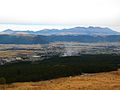 Mount Kujū from Mount Aso
 -
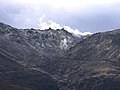 Mount Iō from Chōjabaru
 -
 Mount Hōsshō and Mount Iō from Chōjabaru
 -
 Mount Kujū from Narukogawa Gorge
 -
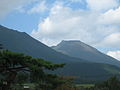 Mount Taisen
 -
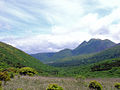
 Kujū Flower Gardens and Kujū Mountains
 -
 Mount Kujū from Makinoto Pass with Mount Mimata on the right


See also
References
- ^ a b c "Japan Ultra-Prominences". Peaklist.org. Retrieved 2015-01-01.
External links
Wikimedia Commons has media related to Mount Kujū.
- Kujusan - Japan Meteorological Agency (in Japanese)
- "Kujusan: National catalogue of the active volcanoes in Japan" (PDF). - Japan Meteorological Agency
- Kuju - Geological Survey of Japan
- "Kujusan". Global Volcanism Program. Smithsonian Institution. Retrieved 2021-06-25.
- v
- t
- e
- Mt. Rishiri
- Mt. Rausu
- Mt. Shari
- Mt. Akan
- Mt. Taisetsu
- Mt. Tomuraushi
- Mt. Tokachi
- Mt. Poroshiri
- Mt. Yōtei
Jōshinetsu region
- Mt. Iwaki
- Hakkōda
- Hachimantai
- Mt. Iwate
- Mt. Hayachine
- Mt. Chokai
- Mt. Gassan
- Mt. Asahi
- Mt. Zaō
- Mt. Iide
- Mt. Azuma
- Mt. Adatara
- Mt. Bandai
- Mt. Aizu-Koma
- Mt. Echigo (Uonuma-Koma)
- Mt. Hiragatake
- Mt. Makihata
- Mt. Hiuchigatake
- Mt. Shibutsu
- Mt. Tanigawa
- Mt. Naeba
- Mt. Myōkō
- Hiuchiyama
- Mt. Amakazari
- Mt. Takatsuma
| Hida Mountains (Northern Alps) | |
|---|---|
| Kiso Mountains (Central Alps) | |
| Akaishi Mountains (Southern Alps) | |
| Others |
|
- Mt. Ibuki
- Mt. Ōdaigahara
- Mt. Ōmine
- Daisen
- Mt. Tsurugi
- Mt. Ishizuchi
- Mt. Kujū (Kokonoe)
- Mt. Sobo
- Mt. Aso
- Mt. Kirishima
- Mt. Kaimon
- Mt. Miyanoura
- Kyūya Fukada
- List of mountains in Japan
- Three-thousanders (in Japan)
 Media related to 100 Famous Japanese Mountains at Wikimedia Commons
Authority control databases | |
|---|---|
| International |
|
| National |
|
| Geographic |
|
 | This Ōita Prefecture location article is a stub. You can help Wikipedia by expanding it. |
- v
- t
- e


