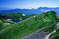
Mount Shirouma
Mountain in the country of Japan


Mount Shirouma
Location of Mount Shirouma in Japan.
Japan
50000:1 白馬岳
Mt. Shirouma (白馬岳, Shirouma-dake) is a peak in the Hida Mountains range of the Japanese Alps, located in Nagano Prefecture and Toyama Prefecture, central Honshu, Japan.
Geography
Mount Shirouma is the 26th-tallest mountain in Japan. At 2,932 metres (9,619 ft), it is the highest peak in the Hakuba section of the Hida Mountains, and one of the top "to climb" peaks for Japanese hikers. It is also one of the few peaks in Japan with year-round snow fields (Firn), in the Shirouma Dai Sekkei, or Shirouma deep-snow gorge (白馬大雪渓).
It is located within the Chūbu-Sangaku National Park.[3] Mount Shirouma is one of the landmark 100 Famous Japanese Mountains.
Alpine plants are also abundant on Shirouma in the summer.[4]
Hiking
There are several popular hiking routes, including the Shirouma Dai Sekkei. This route begins at the Sarukura Lodge (猿倉荘) (1,250m) in the village of Hakuba, and takes approximately 6 hours to reach the summit. Another popular route is via Tsugaike Panorama Way, Hakuba Ooike, and Mount Korenge (2,766m).
There are two lodges near the summit, Hakuba Lodge (白馬山荘) (2,832m) and Hakuba Kousha (2,730m), and tenting is possible at latter. There is also a lodge at Hakuba Oike.
Gallery
-
 Mt. Shirouma and Mt. Korenge in winter, seen from Hakuba, Nagano
 -
 Shirouma-ōike (Shirouma Big Pond), (白馬大池) seen from Mt. Korenge
 -
 Mt. Shirouma and Mt. Korenge in autumn, seen from Mt. Shiroumayari
 -
 Hikers climbing the Shirouma Dai Sekkei from the Sarukura Lodge Route
 -
 Mt. Shakushi and Mt. Shiroumayari, seen from Mt. Shirouma


References
- ^ a b "Map inspection service of 25000:1 白馬岳(富山)" (in Japanese). Geospatial Information Authority of Japan. Retrieved December 16, 2010.
- ^ "Mountains altitude list in Japan(Nagano)" (in Japanese). Geospatial Information Authority of Japan. Retrieved December 16, 2010.
- ^ "Chūbu-Sangaku National Park". Ministry of the Environment (Japan). Archived from the original on February 27, 2012. Retrieved December 16, 2010.
- ^ Sumie Tanaka (1995). New 100 Famous Mountains with Flower(新・花の百名山) (in Japanese). Bunsyunbunko. ISBN 4-16-731304-9.
See also
Wikimedia Commons has media related to Mount Shirouma.
- v
- t
- e
- Mt. Rishiri
- Mt. Rausu
- Mt. Shari
- Mt. Akan
- Mt. Taisetsu
- Mt. Tomuraushi
- Mt. Tokachi
- Mt. Poroshiri
- Mt. Yōtei
Jōshinetsu region
- Mt. Iwaki
- Hakkōda
- Hachimantai
- Mt. Iwate
- Mt. Hayachine
- Mt. Chokai
- Mt. Gassan
- Mt. Asahi
- Mt. Zaō
- Mt. Iide
- Mt. Azuma
- Mt. Adatara
- Mt. Bandai
- Mt. Aizu-Koma
- Mt. Echigo (Uonuma-Koma)
- Mt. Hiragatake
- Mt. Makihata
- Mt. Hiuchigatake
- Mt. Shibutsu
- Mt. Tanigawa
- Mt. Naeba
- Mt. Myōkō
- Hiuchiyama
- Mt. Amakazari
- Mt. Takatsuma
| Hida Mountains (Northern Alps) |
|
|---|---|
| Kiso Mountains (Central Alps) | |
| Akaishi Mountains (Southern Alps) | |
| Others |
|
- Kyūya Fukada
- List of mountains in Japan
- Three-thousanders (in Japan)
 Media related to 100 Famous Japanese Mountains at Wikimedia Commons
Authority control databases | |
|---|---|
| International |
|
| National |
|
 | This Nagano Prefecture location article is a stub. You can help Wikipedia by expanding it. |
- v
- t
- e
 | This Toyama location article is a stub. You can help Wikipedia by expanding it. |
- v
- t
- e


