Quebec Route 214
Highway in Quebec
Major junctions R-112 in East Angus
 R-253 in East Angus
 R-108 / R-255 in Bury
  R-257 in Scotstown
 R-161 in Nantes
- Quebec provincial highways
←  R-213 R-213 | →  R-215 R-215 |
Route 214 is a two-lane east–west highway in Quebec, Canada. Its links Route 112 in East Angus to Route 161 in Nantes via Scotstown, Hampden and Milan.
Municipalities along Route 214
-
 In the town of East Angus, near west end of Route 214.
 -
 Eastward view from Bury.
 -
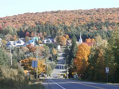
 Quebec Route 214 in Scotstown.
 -
 Victoria street in Scotstown.
 -
 Route 214 entering Milan village.


Major intersections
| RCM or ET | Municipality | Km | Junction | Notes |
|---|---|---|---|---|
Western terminus of Route 214 | ||||
| Le Haut-Saint-François | East Angus | 0.0 | R-112 | 112 WEST: to Ascot Corner 112 EAST: to Dudswell |
| 0.3 | R-253 (North end) | 253 SOUTH: to Cookshire-Eaton | ||
| Bury | 12.4 13.9 | R-108 (Overlap 1.5 km) | 108 WEST: to Cookshire-Eaton 108 EAST: to Lingwick | |
| 16.6 | R-255 (South end) | 255 NORTH: to Dudswell | ||
| Scotstown | 35.3 35.7 | R-257 (Overlap 0.4 km) | 257 SOUTH: to La Patrie 257 NORTH: to Lingwick | |
| Le Granit | Nantes | 63.1 | R-161 | 161 SOUTH: to Lac-Mégantic 161 NORTH: to Stornoway |
Eastern terminus of Route 214 | ||||
See also
References
- ^ Ministère des transports, "Distances routières", page 81-82, Les Publications du Québec, 2005
External links
- Provincial Route Map (Courtesy of the Quebec Ministry of Transportation) (in French)
- Route 214 at Google Maps
- v
- t
- e
 | This Quebec road, road transport or highway-related article is a stub. You can help Wikipedia by expanding it. |
- v
- t
- e


