San Juan National Forest
National Forest in western Colorado
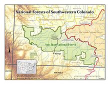
37°33′19″N 107°40′18″W / 37.5553°N 107.6716°W / 37.5553; -107.6716The San Juan National Forest is a U.S. National Forest covering over 1,878,846 acres (2,935.7 sq mi, or 7,603.42 km²) in western Colorado. The forest occupies land in Archuleta, Conejos, Dolores, Hinsdale, La Plata, Mineral, Montezuma, Rio Grande, San Miguel and San Juan Counties.[1] It borders the Uncompahgre National Forest to the north and the Rio Grande National Forest to the east. The forest covers most of the southern portion of the San Juan Mountains west of the Continental Divide. The forest contains two alpine wilderness areas; the Weminuche and South San Juan, as well as the Piedra Area. The Durango and Silverton Narrow Gauge Railroad passes through the National Forest.
The name of the forest comes from the San Juan River, which was originally called the Rio San Juan, after Saint John the Baptist (San Juan Bautista in Spanish).[2][3]
History

Theodore Roosevelt created the forest by proclamation on June 3, 1905. Forest headquarters are located in Durango, Colorado. There are local ranger district offices in Bayfield, Dolores, and Pagosa Springs.[4] President Barack Obama designated part of the forest as Chimney Rock National Monument by proclamation on September 21, 2012.[5]
Wilderness areas
There are three officially designated wilderness areas lying within San Juan National Forest that are part of the National Wilderness Preservation System. All of them extend partially into neighboring National Forests (as indicated).
- Lizard Head Wilderness (partly in Uncompahgre NF)
- South San Juan Wilderness (mostly in Rio Grande NF)
- Weminuche Wilderness (partly in Rio Grande NF)
- Hermosa Creek Wilderness (all on San Juan National Forest)
See also
References
- ^ Table 6 - NFS Acreage by State, Congressional District and County - United States Forest Service - September 30, 2007
- ^ "Map of Juan National Forest" (PDF). Arizona Government. 1961. Retrieved September 11, 2020.
- ^ "Utah History Encyclopedia". www.uen.org. Retrieved 2020-09-11.
- ^ USFS Ranger Districts by State
- ^ President of the United States of America (September 21, 2012). "Establishment of the Chimney Rock National Monument" (pdf). The White House. Retrieved September 21, 2012.
External links
San Juan National Forest at Wikipedia's sister projects
 Definitions from Wiktionary
 Media from Commons
 News from Wikinews
 Quotations from Wikiquote
 Texts from Wikisource
 Textbooks from Wikibooks
 Resources from Wikiversity
- San Juan National Forest (United States Forest Service)
- v
- t
- e

| 43 State Parks |
|
|---|---|
| 1 State Forest | |
| 307 State Wildlife Areas | |
| 96 State Natural Areas |
|
| 26 Scenic and Historic Byways |
|
| 28 National Recreation Trails |
|
|---|---|
| 6 Regional Trails |

Authority control databases | |
|---|---|
| International |
|
| National |
|
| Other |
|


