Elkhorn Slough National Estuarine Research Reserve
Facility in Watsonville, United States

The Elkhorn Slough National Estuarine Research Reserve is a nature reserve that is located at 1700 Elkhorn Road in Watsonville, California.[1] The reserve encompasses the central shore of Monterey Bay and is approximately 100 miles (160 km) south of San Francisco, California.[2] The Elkhorn Slough is established as a part of the National Oceanic and Atmospheric Administration and is being managed as the Elkhorn Slough Ecological Reserve through the California Department of Fish and Wildlife.[3]
Description
The mission of the 1,700-acre (6.9 km2) Elkhorn Slough National Estuarine Research Reserve is to promote the environmental education, research, and protection of ecosystems found in Elkhorn Slough salt marsh along with the surrounding watershed.[4] There are programs hosted that work towards conserving and protecting the wildlife and habitats in Elkhorn Slough, as part of the National Estaurine Research Reserve system.[5]
Recreational and Educational Activities

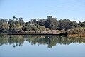
The visitor center features exhibits and five miles (8 km) of trails that offer a diverse variety of plants and animals to see.[4] This reserve also serves as a spot for kayaking and birding as well, where visitors can be surrounded by seals, fish, sea otters, and marshes.[6] The Elkhorn Slough also contains various species of leopard sharks, birds, and fish that are considered to be threatened habitats.[4] Visitors can observe these forms of wildlife in the watershed while learning more about these rare estaurine communities.[4]
-
 Students Observing Elkhorn Slough 2016
 -
 Pier at Elkhorn Slough 2016
 -
 Trail at Elkhorn Slough 2008


References
- ^ "Elkhorn Slough National Estuarine Research Reserve". www.wildlife.ca.gov. Retrieved 2019-10-12.
- ^ "OP-11: Biodiversity | San Jose State University | Scorecard | Institutions | STARS Reports". Retrieved 2019-10-12.
- ^ "Elkhorn Slough Reserve". Elkhorn Slough. 2015-10-12. Retrieved 2019-10-12.
- ^ a b c d "Press Release: Elkhorn Slough Designated "Wetland of International Importance"". Elkhorn Slough. 2018-10-06. Retrieved 2019-10-13.
- ^ "About Elkhorn Slough". Elkhorn Slough. 2016-05-29. Retrieved 2019-10-13.
- ^ "Elkhorn Slough National Estuarine Research Reserve". archive.is. 2012-07-30. Archived from the original on 2012-07-30. Retrieved 2019-10-13.
External links
Wikimedia Commons has media related to Elkhorn Slough National Estuarine Research Reserve.
- Elkhorn Slough National Estuarine Research Reserve (ESNERR) - official website operated by the Elkhorn Slough Foundation
- Elkhorn Slough National Estuarine Research Reserve at the California Department of Fish and Wildlife
- Elkhorn Slough National Estuarine Research Reserve at the National Estuarine Research Reserve System
- v
- t
- e
- Apalachicola
- Ashepoo Combahee Edisto Basin
- Bahía de Jobos
- Chesapeake Bay
- Chesapeake Bay
- Delaware
- Elkhorn Slough
- Grand Bay
- Great Bay
- Guana Tolomato Matanzas
- He‘eia
- Hudson River
- Jacques Cousteau
- Kachemak Bay
- Lake Superior
- Mission-Aransas
- Narragansett Bay
- North Carolina
- North Inlet-Winyah Bay
- Old Woman Creek
- Padilla Bay
- Rookery Bay
- San Francisco Bay
- Sapelo Island
- South Slough
- Tijuana River
- Waquoit Bay
- Weeks Bay
- Wells
 Category
 Commons


